
![]()
A Summary of the Flood Warning Process for Thames Ditton (Mainland)
Floodline: 0345 988 1188
Introduction
On 4th January 2018 a Flood Alert for Thames Ditton was issued by the Environment Agency (EA).
This note has been produced mainly by the EA, with updates (in green) by the Residents Association to explain the flood alert and flood warning process that specifically applies for Thames Ditton and the surrounding areas.
Over the next few months some of the detail will be updated as a result of on-going work on the River Thames Scheme. Also, the Residents Association Flood Group is working at a finer level of detail to develop a Community Flood Plan that will enable us to provide more detailed flood warning information that will, for example, indicate when residents in particular streets should move cars and take other necessary action. The Flood Plan will also provide more detailed information on what to do in the event of a flood.
Critical to understanding flood warnings is the actual river height. For Thames Ditton there is a measuring station opposite Thames Ditton Island, as described later in this note. The actual measured river heights are relatively meaningless in absolute terms, but the important points are that normal summer river height is around 4.5m AOD (related to a local datum). During the worst flooding in February 2014 the level went up to a peak of around 6.7m, which affected several properties in the area. The recent flood alert was for a level of 5.15m – although the level actually went up to 5.4m.
Assessing Flood Risk
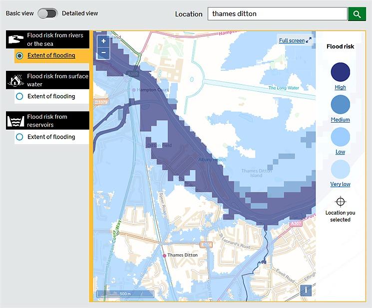
You can assess your long term flood risk on our website:
https://flood-warning-information.service.gov.uk/long-term-flood-risk/map
This information is used for lots of purposes including people submitting permit and planning applications and buying properties. It is useful to find out if a property is at risk but unlikely to be useful for your purposes after that initial stage unless you need to demonstrate the flood risk to other residents. There are data sets for fluvial, surface water and reservoir flooding.
Note that detail for flood risk from rivers is relatively crude and in detail seems incorrect based upon detailed maps that we have. Also, there are no Medium Risk levels included for TD. It will be updated by Environment Agency in 2018.
It is important to understand what this general information means in relation to river heights and potential flood warnings as well as what do the various risk levels actually mean.
Firstly the risk levels are given numerically as an AEP (Annual Exceedance Probability). This is a percentage that shows the likelihood that the associated river level will be reached in any year. For example, a 20% AEP means that in any year, there is a 20% chance that the associated river level will be reached. The second method is to show a ratio such as 1 in 5 or 1:5. This means effectively the same that in any year there is a 1 in 5 chance of the river level being reached, which is the same as a 20% chance. The ratios commonly used by Environment Agency and the associated river height level for Thames Ditton and their relationship to risk are as follows:
20% AEP (1:5) 6.28m
5% AEP (1:20) 6.97m
3.33% AEP (1:33) (level not known, but must be around 7.1m)
(High risk of flooding – see plan above)
2% AEP (1:50) 7.32m
1%AEP (1:100) 7.62m (Medium risk of flooding)
0.1%AEP (1:1000) 8.7m (Low risk of flooding)
Signing up for Warnings
You can sign up for flood warning and alerts either online https://www.gov.uk/sign-up-for-flood-warnings or by calling Floodline (0345 988 1188). In addition some phone numbers are automatically signed up based on living in flood warning areas using their landlines and some mobile phone networks and although they can opt-out of this system most people tend not to do so.
When you sign up online you can see the extent of the flood warning area and flood alert area as you progress through the process. This only happens if you ignore entering your Post Code on the web page but search by Town or City and input Thames Ditton.
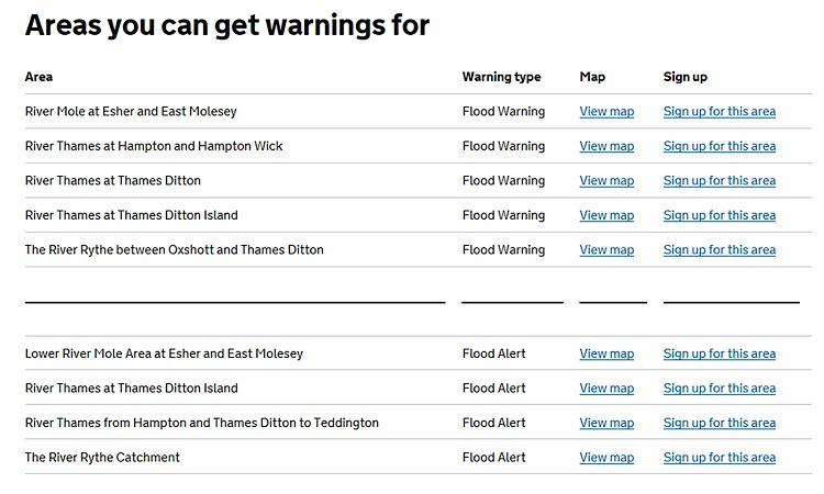
Flood Warning Areas
Below is an extract of our mapping system showing the flood warning area you are located within. As you can see the island is not included - that has a separate flood warning area. The flood warnings you receive only relate to this yellow area. The flood warning on Thames Ditton Island will be issued before your flood warning as the threshold (i.e. river level for issuing) is lower.
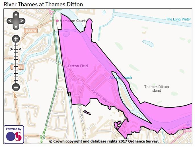
Plan of Flood Warning Area
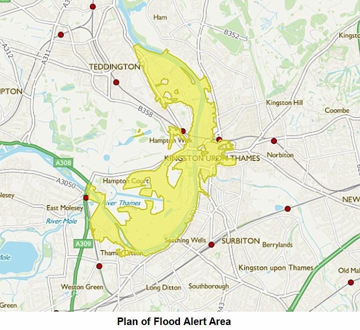
Flood Alerts
Flood alert areas are usually much bigger than a flood warning area, as is the case in your area as shown below.
Again Thames Ditton Island has its own flood alert area.
Quite a few people choose not to receive flood alerts. These are issued more frequently, and warn of flooding to low lying land and roads rather than property flooding. Instead they will just receive flood warnings. You can check whether you have chosen to receive both and opt in/ out by calling Floodline.
As a brief reminder, the three different warnings and the relevant levels for Thames Ditton:
- Flood alert = river out of banks - 5.7m (not correct – being updated)
Flood warning = property flooding expected – 6.66m (and 6.35m for TD Island)
Severe flood warning = based on impacts rather than river level threshold, eg. threat to life
Note that 5.7m is unlikely to cause any problem to mainland residents and at 6.66m some properties are likely to be already flooded and certainly some cars should have been moved.
When flood alerts and flood warnings are issued you receive a phone call, text or email depending on what method you selected when you signed up. You can update these details by calling Floodline.
In order to get the full details of the flood alert or warning you will need to look at our pages on the internet:
https://flood-warning-information.service.gov.uk/warnings or call Floodline (0345 988 1188).
Exactly the same wording is used on the website and by the recorded message on Floodline. There are also some twitter accounts which publish this information: https://twitter.com/FloodAlerts
The wording of the alert or warning will include:
Whether property flooding is expected
The current river situation and what is forecast to happen
Brief details of the flooding expected (e.g. “properties closest to the river are expected to flood)
What action you can take
The action we are taking (e.g. “our field teams are out in the area inspecting flood defences and trash screens”)
We usually update the wording of the warning or alert twice a day with current information about levels and forecast, and it will be issued at least two hours before any impacts but with more notice where possible. Flood alerts are only issued in daytime hours (7am-10pm). Flood warnings can be issued at any time although we will try not to issue them during the night if at all possible.
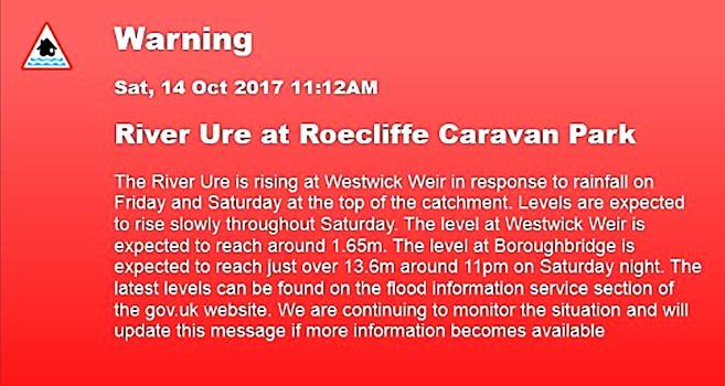
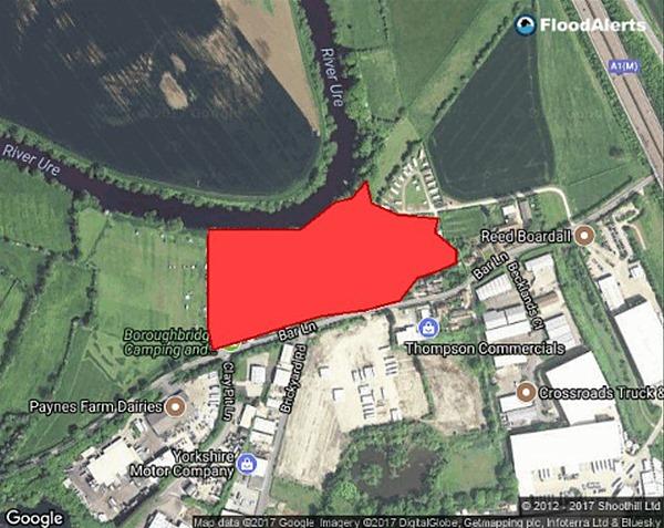
The warning also includes a map of the relevant area. The map will show the whole flood warning area even if only part of it is at risk. In the example below the small red highlighted area is the flood warning area (this example doesn’t have details about property flooding as it is a caravan park)
This is an example of a flood warning – it is from outside of the Thames area as we haven’t needed to issue any warnings for over 12 months.
Flood Alert 4th Jan 2018
This is an extract from the relevant Flood Alert email.
A Flood Alert has been issued by the Environment Agency.
Flood Alert in force: River Thames from Hampton and Thames Ditton to Teddington.
Flooding is possible for: River Thames from Hampton and Thames Ditton to Teddington including Hampton Wick and Kingston-upon-Thames.
Be prepared.
The next high tide is expected at 5:00am on Friday at Molesey. River levels are forecast to reach approximately 5.15 metres. Flooding of low lying land adjacent to the river in the Molesey and Kingston areas is possible. The following high tide is expected at 5:45pm on Friday and is forecast to reach approximately 5.05 metres. Flooding of low lying land and roads is currently not expected for this high tide. People are advised to stay away from risk areas and take care. Property flooding is not expected for either high tide.
This was subsequently updated to increase the forecast to 5.4m.
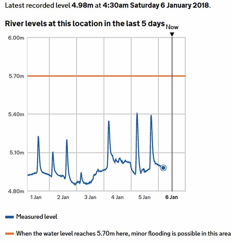
The actual river levels measured by Thames Ditton Island are shown below. The impact of high tide is clearly seen. Also, the forecast level in the initial Flood Alert has been significantly exceeded – although the revised forecast was correct.
As far as Thames Ditton is concerned, the Alert was of no relevance but maybe more important in Kinston – where the measuring station showed the river level to be approximately 0.3m lower.
Residents' Association Actions
The Residents Association has detailed land height information available (supplied by the Environment Agency) for the main at risk area of Thames Ditton. We are developing our own system of analysis which will enable much more targeted alerts and warnings to be provided to residents. This will probably include advice for when to move cars and when to take action to protect your home.
River levels on the internet (RLOI)
https://flood-warning-information.service.gov.uk/river-and-sea-levels
Both Thames Ditton, and Thames Ditton Island are monitored using the same gauges:
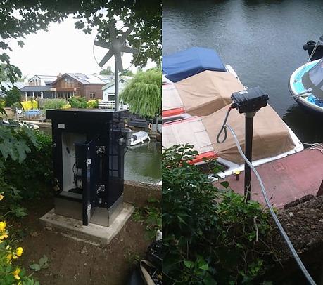
The output from the gauge is available on the internet as shown for the Flood Alert above.
The level shown for potential flooding relates to the whole flood warning area – it is the same threshold we use for issuing flood alerts, ie. the river is coming out of banks. It is not the threshold for property flooding. You will note that we update the level data more frequently if there is a flood risk.
The five day flood risk is only intended to give a high level overview of the levels of risk in regions and nationally– we use a similar system internally to give an idea of the overall flood risk as the weather forecast and river models cannot reliably look this far ahead.
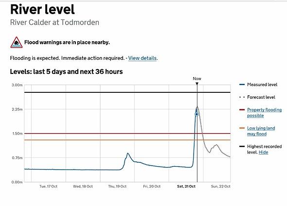
We are currently developing a project to show forecast river levels on the same webpage. The pilot sites (none in our area) have been tested successfully and are now live (search for the Calder Valley sites on RLOI to see what they look like https://flood-warning-information.service.gov.uk/station/8048) so there will be a wider roll-out coming next year. I have requested that the Thames Ditton gauge is included and will let you know once I have further information. It will however only be forecasting up to 36 hours in advance as that is all the weather, and river models, allow.
This is an example from the pilot:
This note was primarily prepared by Maddy Adams of the Environment Agency, with additional information (in green) included by Tony Thompson, the Chairman of the Residents' Association Flooding Sub-committee. If you require further information please contact Tony in the first instance at aathompson_uk@yahoo.co.uk .
7th January 2018